
The goal of Co-HYDIM-SA
Co-HYDIM-SA addresses critical need for hydrometeorological early warning and information systems (EWIS) to optimize water resources management and thereby enhance water security in Southern Africa. This will be achieved through a transdisciplinary approach by combining scientific, academic and operational expertise in the fields of meteorology, hydrology, and risk assessment with the expertise of river basin authorities, water resource and dam managers. Key innovations of the project include:
- Leveraging the novel capabilities of sub-seasonal to seasonal hydrometeorological forecasting,
- Enhancing the accuracy and details of seasonal forecasting,
- Linking hazard monitoring and forecasting to actual risk reduction, and
- Providing a proof of concept for enhanced monitoring and early warning of hydro-climatic components in two transboundary catchments: the Cuvelai-Cunene and the Upper Limpopo basins.
Geographical location and impact

Co-HYDIM-SA will focus on two transboundary catchments: the Notwane transboundary catchment in the Upper Limpopo basin, and the Cuvelai-Cunene transboundary basin in northern Namibia and southern Angola.
In the Upper Limpopo basin, the project will collaborate closely with the Water Utility Corporation (WUC), which manages the Gaborone dam, the primary source for the city of Gaborone. Together with WUC, we will co-develop an Early Warning & Information system (EWIS) aimed at improving the dam management based on forecast of water inflow into the Gaborone reservoir for several weeks to months. In the Cuvelai-Cunene catchment, the Cuvelai Basin Early Warning & Information System (CUVEWIS) will be co-developed with the Cuvelai Watercourse Commission (CUVECOM). This system will integrate hydro-meteorological information to enhance monitoring and early warning of important hydro-climatic components in the cross-border catchment. Both EWIS and CUVEWIS will be implemented operationally in pilot versions at WUC and CUVECOM, respectively.
Structure and workpackages
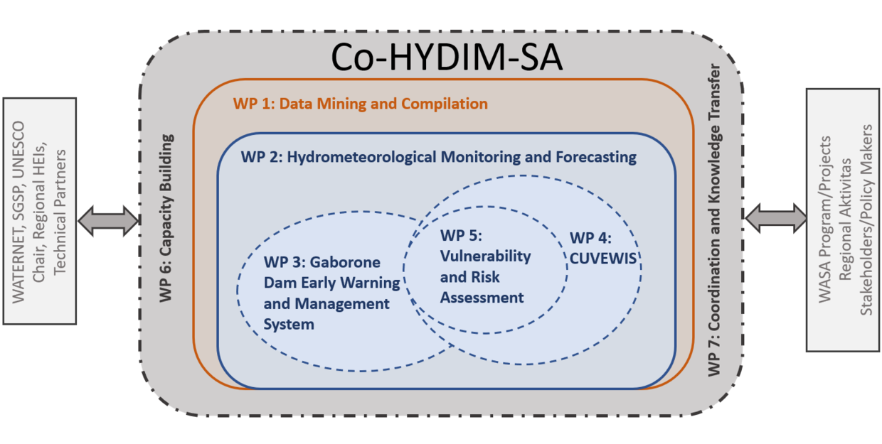
WP1: Data Mining and Compilation
Lead partners: KIT-IMKTRO, UNAM
The main objective of WP1 is to significantly improve the availability of quality-controlled, hydrometeorological (observational, model-based) and socio-economic data for the study regions. Additionally, WP1 aims to transfer the data repository to suitable organizations within the region, ensuring its long-term sustainability beyond the project's conclusion.
WP2: Hydrometeorological Monitoring and Forecasting at the Pan-Southern African Scale
Lead partners: KIT, BIUST
The overall aim of WP2 is to enhance and operationalize regional hydro-meteorological monitoring and forecasting capabilities, with a particular focus on early warning of hydro-meteorological hazards at the regional scale, tailored to the needs of decision-makers. In the area of rainfall monitoring and user-specific sub-seasonal and seasonal forecasting, we will closely cooperate with world-leading partners.
WP3: Gaborone Dam Water Level Early Warning and Management System
Lead partners: BIUST, KIT
In this WP, the EWIS system will be designed to address the priorities of WUC and other water authorities, incorporating functionalities for monitoring droughts as well as sub-seasonal and seasonal forecasting of droughts and wet spells. Hydrological models will be deployed to quantify the water inflow and outflow of the dam for the coming weeks and months. A prototype EWIS system will be implemented at WUC and tested in an operational setting during the second part of the project.
WP4: CUVEWIS (Early Warning-supporting Hydrometeorological Information System for the Cuvelai)
Lead partners: ICWRGC/BfG (International), CUVECOM/GHABIC
Here, the priorities of CUVECOM’s will be addresed. The CUVEWIS system will ´be designed, incorporating functionalities for monitoring and (sub-)seasonal forecasting of droughts and wet spells. It will feature a prototype warning component for both hazards based on a traffic light approach. To address water-related risks and vulnerabilities for the population, this system design will be informed by a risk and vulnerability assessment in WP5.
WP5: Vulnerability and Risk Assessment
Lead partners: UoB, UNAM
In the Cuvelai – Cunene and Limpopo River Basins, where 1.7 million and 18.8 million people reside respectively, a coherent vulnerability and risk approach is crucial. This approach will integrate collaborative modeling and stakeholder engagement to inform sustainable water-related risk reduction strategies, addressing the challenges posed by both floods and droughts.
WP6: Technical and Academic Capacity Building
Lead partners: ICWRGC/BfG, CUVECOM
One goal of WP6 is to organize and deliver a capacity-building workshop on the use and application of project-related models and tools, as well as broader topics related to integrated river basin management and data management. Another key objective is to actively contribute to regional education programs in Southern African.
WP7: Technical and Academic Capacity Building (Project coordination and knowledge transfer)
Lead partners: KIT, BIUST
WP7 provides the essential tools to ensure an efficient and effective project implementation and facilitate interaction with the WASA program partners and beyond. It assures an effective scientific, administrative, financial and risk management, and coordinates the interaction and feedback loops between partners and Co-HYDIM-SA stakeholders and associated partners. Additionally, WP7 serves as a link to the project management agency, the network and transfer project, and the other WASA projects.